

|
Cultural attractions Historic sites, ancient ruinsGarni Temple and the Symphony of Stones Erebuni Fortress and Museum Zvartnots Temple Black Fortress Areni Village Megalithic Complex Karahunj Cave City Khndzoresk Caravanserai on the Selim Pass Medieval Cemetery Noratus Amberd Fortress Village of Old Khot Smbataberd Fortress Yereruyk Basilica Dashtadem Castle Bjni Fortress Berdavan Fortress Sevsar Petroglyphs Lori Berd Fortress Monasteries, cathedrals Architectural attractions Natural attractions Unusual attractions |
Garni Temple and the Symphony of Stones (Garni Gorge) R1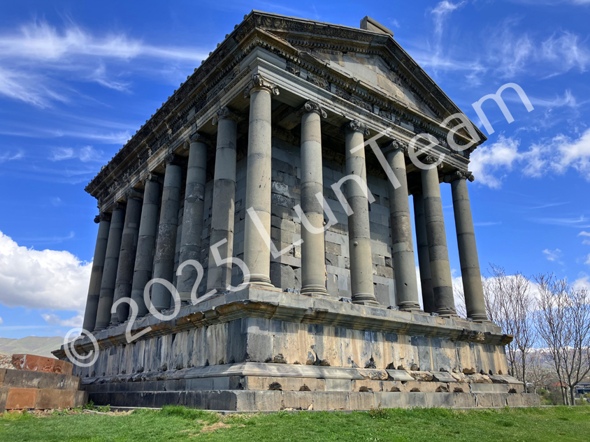
Garni Temple - an ancient structure in Armenia, built in the 1st century AD by the Armenian king Trdat I. It is located 28 km from Yerevan, in the valley of the Azat River, near the village of Garni and within the territory of the Garni Fortress. The temple was destroyed by an earthquake in 1679, but was restored in the 1970s. This majestic building resembles Greek temples. Constructed during pre-Christian Armenia (66–88 AD), it was most likely dedicated to Mher - the god of the sun and justice. Garni is a popular tourist destination. It stands on a hill, offering a beautiful view of the surrounding landscape. The architecture of the temple reflects a style typical of Ancient Greece, which is explained by the close ties between the Armenians and the Greeks. The Temple of Garni was part of a larger complex that included Roman baths, the king’s summer residence, and a 7th-century church. The most remarkable feature is the mosaic floor of the baths, made of 15 types of natural stone. In 2011, the Garni complex was awarded the UNESCO Melina Mercouri Prize. Next to the temple lies the famous gorge known as the “Symphony of Stones” or “Stone Organ.” This geological formation consists of perfectly shaped hexagonal basalt columns resembling organ pipes. On the way out of Yerevan, it's worth stopping at the Charents Arch, which offers a magnificent view of the Ararat Valley. Nearby is also the Geghard Monastery - a unique architectural complex carved into the rock, located in a picturesque mountainous and forested area. The Temple of Garni is an important historical landmark representing the era of paganism and Hellenism. It survived almost intact until the late 17th century, when it was destroyed by an earthquake. In the 19th century, French scholar Dubois de Montpereux proposed a reconstruction project that was eventually carried out in 1966. Today, the temple is fully restored, and visitors can enjoy its grandeur. >>>>>>>>>>>>>>>>>>>>>>>>>>>>>>>>>>>>>>>>>>>>>>>>>>>>> Book a tour to Garni Temple and the Symphony of Stones 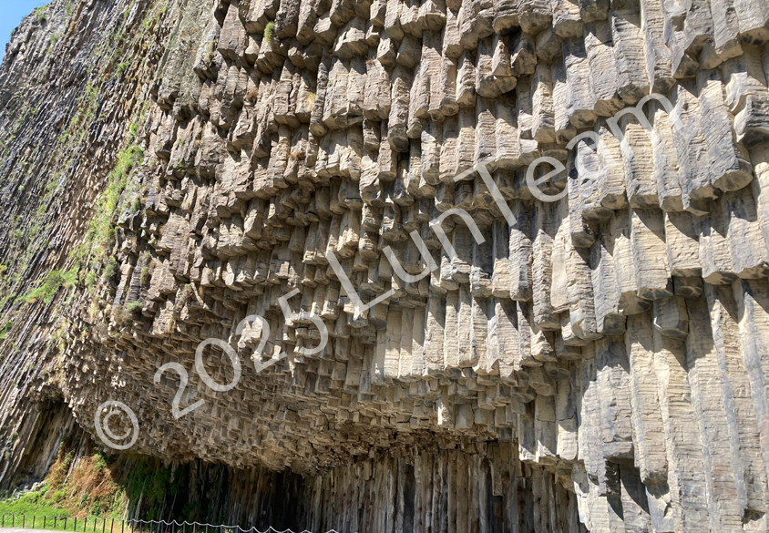
Erebuni Fortress and Museum (Yerevan) R1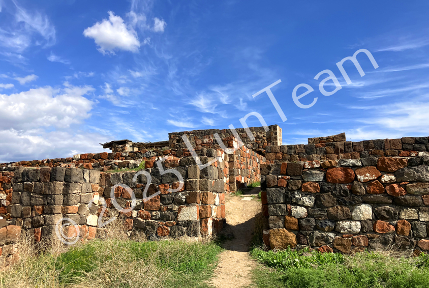
Many civilizations have vanished into history, but not all have survived to our time. One such lost state is Urartu, which ceased to exist in the 6th century BC. From this ancient kingdom, only archaeological findings and the ruins of cities have survived. One of the best-preserved among them is Erebuni, founded around 780 BC in the area of modern Yerevan. In its prime, the city was an important agricultural center, supplying grain to other regions of Urartu. However, after a series of military defeats and economic decline, Erebuni gradually became deserted and eventually ceased to exist. For more than two thousand years, nothing was known about it, until archaeologists excavated the remains of the city in the mid-20th century. Thanks to these excavations, the architecture of the fortress was partially reconstructed, and today it is considered one of the oldest fortresses in the world. After walking through the ancient streets, it is worth visiting the museum to learn more about the history of Erebuni. Yerevan is one of the oldest cities in the world - it is at least 2,804 years old. The chronology of Armenia’s capital begins with the Erebuni Fortress, built in 782 BC by the Urartian king Argishti I. During excavations, archaeologists discovered various artifacts, including gold and silver items, as well as 23 cuneiform tablets that provided valuable information about the Urartian period. These tablets are preserved in the Erebuni Historical-Archaeological Museum-Reserve, which is an important center for the study of this ancient state. Erebuni is the only archaeological monument in Yerevan open to the general public. Located on a hill overlooking the city, it is a unique landmark that attracts visitors with its impressive panoramic views of Yerevan. Zvartnots Temple (Armavir) R2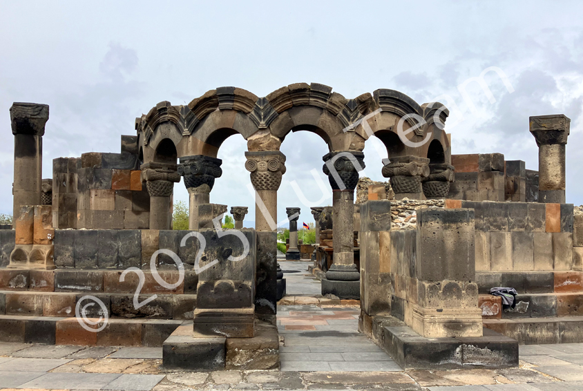
The Zvartnots Temple, now lying in ruins, was one of the most magnificent churches in Armenia in the 7th century and had a significant influence on Christian architecture. The construction of the cathedral was completed in 650 CE, and the Byzantine Emperor Constans II attended its opening. He was so impressed that he ordered a similar church to be built in Constantinople. The cathedral was destroyed by an earthquake in the 10th century and remained lost for many centuries until it was rediscovered in the early 20th century. Only the first tier has been restored. Zvartnots was built at the initiative of Catholicos Nerses III the Builder in 661 and remained an active church until the late 10th century. Excavations at the site uncovered the ruins of the structure itself, as well as the Catholicos’ chambers, baths, monks’ cells, various household items, and graves. A stone winery was found near the cathedral. The name “Zvartnots” translates from Classical Armenian as “Temple of the Heavenly Angels.” Its ruins, including a partially preserved colonnade, are located near the airport of the same name on the way to Yerevan. Within the territory of the historical and cultural museum-reserve - listed as a UNESCO World Heritage site - visitors can see numerous sculptural fragments, an arched colonnade decorated with bas-reliefs of grapevines and pomegranate fruits, as well as large stone slabs carved with figures. Of particular interest is a sundial discovered during the excavations. The museum’s exhibition also features artifacts such as colored ceramics, jewelry, metal tools, and other household items. The reserve has free parking, and entrance requires purchasing the Yerevan Card, which includes all major attractions of the capital. >>>>>>>>>>>>>>>>>>>>>>>>>>>>>>>>>>>>>>>>>>>>>>>>>>>>>>>> Book a tour to Zvartnots Temple Black Fortress (Gyumri, Shirak) R8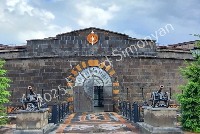
The Russo-Persian War of 1804–1813 ended with Persia’s defeat and the signing of the Treaty of Gulistan. Among other provisions, the treaty transferred a significant part of the South Caucasus, including the city of Gyumri, to Russian control. Due to tense relations with Turkey and the proximity of the border, the Russian authorities decided to strengthen the newly acquired frontiers. It was during this period that a fortress was built, later called the Black Fortress because of the color of its stone - basalt. The stronghold played an important role in Russia’s victories in the Russo-Turkish wars, although the fortress itself was never besieged. Initially, it was managed by the Ministry of Defense, but several years ago it was purchased and turned into a publicly accessible landmark. >>>>>>>>>>>>>>>>>>>>>>>>>>>>>>>>>>>>>>>>>>>>>>>>>>>>> Book a Tour in Gyumri Areni Village (Vayots Dzor) R4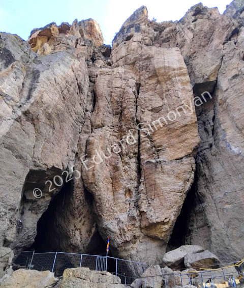
For centuries, the village of Areni served as the capital of Syunik, an important strategic point, and a resting place for travelers and trade caravans. This is explained by its location at the exit of the gorge connecting the Harur Valley with the Vayots Dzor region. The past is echoed in the ruins of fortresses, the Ishkhan’s palace, and the Church of the Holy Mother of God. Among the village’s main attractions is the Areni Cave, known for its valuable archaeological discoveries. Its unique microclimate contributed to the excellent preservation of artifacts, allowing scientists to uncover new evidence of ancient eras. Every year, on the first Saturday of October, a Wine Festival is held here. Its tradition is based not only on local winemaking practices but also on a significant archaeological find - the ancient winery over 6,000 years old, recognized as the oldest in the world. Megalithic Complex Karahunj (Syunik) R5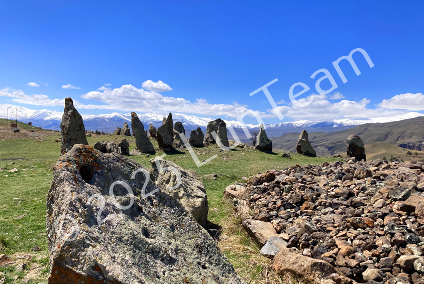
Not far from the town of Sisian lies the megalithic complex Karahunj, also known as Zorats Karer. At first glance, these stone blocks seem to be part of the natural landscape, but in fact they were placed by humans. The exact date of their construction remains a subject of debate, with estimates ranging from the 5th to the 2nd millennium BCE. The purpose of the complex is still not fully understood. It is believed that it might have served as a livestock enclosure, as suggested by the holes in the stones through which ropes could be threaded. Burials discovered beneath the boulders also indicate a funerary function. There is a hypothesis that Karahunj was used as an ancient observatory, but it has not been scientifically confirmed. Karahunj is often compared to Stonehenge, yet it is unique and, in the opinion of many visitors, has a special atmosphere. Cave City Khndzoresk (Syunik) R5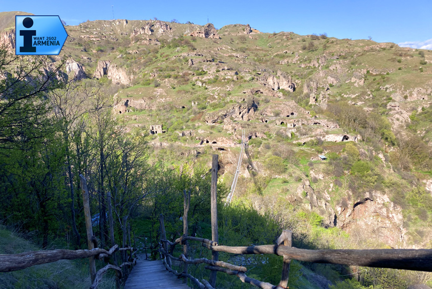
The village of Khndzoresk is one of Armenia’s most visited attractions. The first mentions of it appear in 12th-century tax records, where it is listed as a taxpayer to the Tatev Monastery. Khndzoresk is unique in that its dwellings were carved directly into the cliffs, forming peculiar “multi-story” structures: the roof of one home served as the floor of another. Some dwellings were located so high that they could only be reached by ropes - this allowed the locals to defend themselves from nomadic raids. The village reached its peak by the early 20th century, becoming the largest settlement in Eastern Armenia. It had 27 shops and 7 schools. During World War II, about 1,300 residents went to the front, 480 of whom never returned. Many villagers received military honors, and one even rose to the rank of general. Today, Khndzoresk attracts tourists with its ancient landmarks: the Church of Saint Hripsime (1663), the 17th-century Church of Saint Tadevos, the ruins of the Anapat church school, and the grave of national hero Mkhitar Sparapet. An unforgettable view of the gorge opens from the suspension bridge installed in 2012. Its swaying structure makes crossing it a true challenge for thrill-seekers. >>>>>>>>>>>>>>>>>>>>>>>>>>>>>>>>>>>>>>>>>>>>>>>>>>>>> Book a tour to Cave City Khndzoresk Caravanserai on the Selim Pass (Vardenyats) (Vayots Dzor) R4A caravanserai was a predecessor of modern inns, where merchants and travelers along trade routes could rest. One such caravanserai was built in the 14th century on the Vardenyats Pass, through which the Great Silk Road once passed. For Armenians, it was known as an ijevanatun. The building’s architecture was innovative for its time, and its excellent state of preservation makes it a valuable historical monument. According to written sources, many notable travelers passed through this route, including Marco Polo. In his accounts, he described Armenia, its mountain roads, artisan traditions, and healing springs. A tragic legend is also associated with the caravanserai. It is said that the son of a Kurdish leader, Suleima, fell in love with a girl from the Gegharkunik region and often visited her. One winter, during a severe snowstorm, he lost his way and died from the cold. In memory of his son, his father built the caravanserai so that weary travelers could find shelter from bad weather. Medieval Cemetery Noratus (Gegharkunik) R4The Noratus cemetery is the largest necropolis featuring khachkars, which are used here as tombstones. It contains around a thousand monuments, the oldest of which date back to the 10th century. In scale, Noratus surpasses all similar cemeteries except for the necropolis in Julfa, Azerbaijan, which was destroyed in 2005. A legend is associated with this place concerning the invasion of Tamerlane. It is said that when expecting an attack, the local residents placed helmets on the khachkars and attached swords to them, creating the illusion of a vast army. Deceived, Tamerlane’s forces retreated. Near the cemetery lies the ancient Church of the Holy Mother of God, founded more than a thousand years ago. Amberd Fortress (Aragatsotn) R6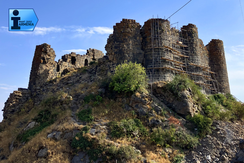
Amberd Fortress, located at an altitude of 2,300 meters on the slope of Mount Aragats, has been known since ancient times. Sources suggest that its main structures were built as early as the 7th century, during the rule of the Kamsarakan dynasty. Later, in the 11th century, the fortress came under the control of the Bagratuni princes, who began large-scale construction. Today, only the ruins of the castle remain, but the church built during that period has survived better than the other structures. In 1236, the fortress was destroyed and abandoned by the Mongols. Underground passages lead from the fortress down into the gorge; some have been preserved, while others have collapsed. It is possible that future researchers may uncover their secrets, but for now, the ancient tunnels remain inaccessible guardians of history. >>>>>>>>>>>>>>>>>>>>>>>>>>>>>>>>>>>>>>>>>>>>>>>>>>>>> Book a tour to Amberd Fortress Village of Old Khot (Syunik)Sixty-seven kilometers northeast of Kapan lies the village of Khot, whose history reaches deeper into the past than that of Machu Picchu. In the old part of the village, burials dating to the 2nd–1st millennia BCE have been preserved, as well as the ruins of the 12th-century Red Church. According to legend, the church was built by an Armenian woman who escaped from the harem of the Persian shah Abbas. Its bell had such a powerful sound that it could be heard throughout the entire region, and the name of the area, Zangezur (“zang zor” - “powerful bell”), is said to originate from this ringing. Unlike Machu Picchu, which was abandoned in the 16th century, Khot remained inhabited until the 1970s. The residents then relocated farther north to an area more suitable for living, where the modern village is now located. Smbataberd Fortress (Vayots Dzor)Smbataberd Fortress was one of the largest and most impregnable strongholds in the Vayots Dzor region. Sheer cliffs protected it on three sides, and the only entrance was from the north, where massive gates once stood. Inside the fortress, archaeologists discovered the ruins of barracks and reservoirs. It is believed that the fortress was built on the site of an older observation post founded in the 5th century, and during the Armenian–Persian wars it was reinforced to its maximum level. The fortress’s original name remains unknown, and its modern name is linked to the figure of Smbat. According to one version, it refers to an Armenian king buried in the village of Yeghegis, who may have rebuilt the fortress. Another version connects the name to Prince Smbat of Syunik, who lived in the 10th century. The second hypothesis is considered more likely. Yereruyk Basilica (Shirak)In the village of Anipemza, on the left bank of the Akhuryan Gorge and five kilometers from the ancient capital of Ani, stands the Yereruyk Basilica - one of the oldest Christian structures in Armenia. The church, built of light orange tuff, dates to the 4th–7th centuries and is included on the UNESCO World Heritage List. Thanks to the unusual design of its columns, an optical illusion is created, making the building appear to sway slightly when viewed from afar. Dashtadem Castle (Aragatsotn)Dashtadem Fortress stands out among Armenian fortresses in that it lacks any natural defensive barriers - no gorges, cliffs, or rivers. Its security depended solely on its massive walls. Another distinctive feature is the absence of nearby water sources. The inhabitants collected water in a reservoir and were forced to use it extremely sparingly during sieges. The exact date of the castle’s construction is unknown, but specialists believe it was built on the site of an older Urartian fortification. Its construction likely began between the 5th and 7th centuries. Bjni Fortress (Kotayk)Bjni is a vivid example of medieval fortification architecture and one of Armenia’s important cultural centers of the time. Valuable manuscripts created and preserved here date from the 12th to the 17th centuries. According to legend, the fortress and the Bjni Monastery were connected by an underground passage through which food and water were delivered on carts during sieges. However, the fragment of a tunnel discovered during excavations does not support this version. Many researchers believe that the story of the underground road is more likely a legend created by the defenders of the fortress. Berdavan Fortress (Tavush) R7Berdavan Fortress, also known as Galinjakar, is one of the best-preserved medieval Armenian fortresses. It was first mentioned in written sources in 1123 and was likely reconstructed during a later period. A collection of ancient khachkars has been preserved on the fortress grounds. In 1983, extensive restoration work was carried out here: the upper sections of the walls and towers were reinforced, and two northeastern towers were restored. Sevsar Petroglyphs (Gegharkunik)The ancient astrological complex on Mount Sevsar in the Vardenis Range is located 8 km from the village of Geghovit at an elevation of 2,650 meters. The largest stone, covering an area of 6 square meters, is decorated with carvings depicting humans, a horse, vishaps (dragons), stars, whales, circles, a cross, a crescent, and other symbols. Interpretations of these images vary. Some researchers believe that the circular design represents a sundial, with the surrounding symbols indicating days. According to another theory, it portrays a rare phenomenon in the form of a fireball, while the surrounding signs denote constellations. The most convincing hypothesis is considered to be that of B. Tumanyan: the three rays extending from the central image indicate the location where a meteorite fell, presumably near the summit of Mount Azhdahak (3,597 m). In the northwestern part of Azhdahak’s volcanic cone, at an altitude of 2,310 meters, a depression was discovered measuring 4 meters deep and 28×35 meters across. It may have been left by a meteorite weighing 80–300 kg that struck at a speed of 10–20 km/s. This could indeed be the trace of the mysterious cosmic object. Lori Berd Fortress (Lori) R7
Lori Berd Fortress |
| info@iwant2go2armenia.ru | © 2025 LunTeam |
|---|